Castle Atlas / No. 2
Goryōkaku
五稜郭
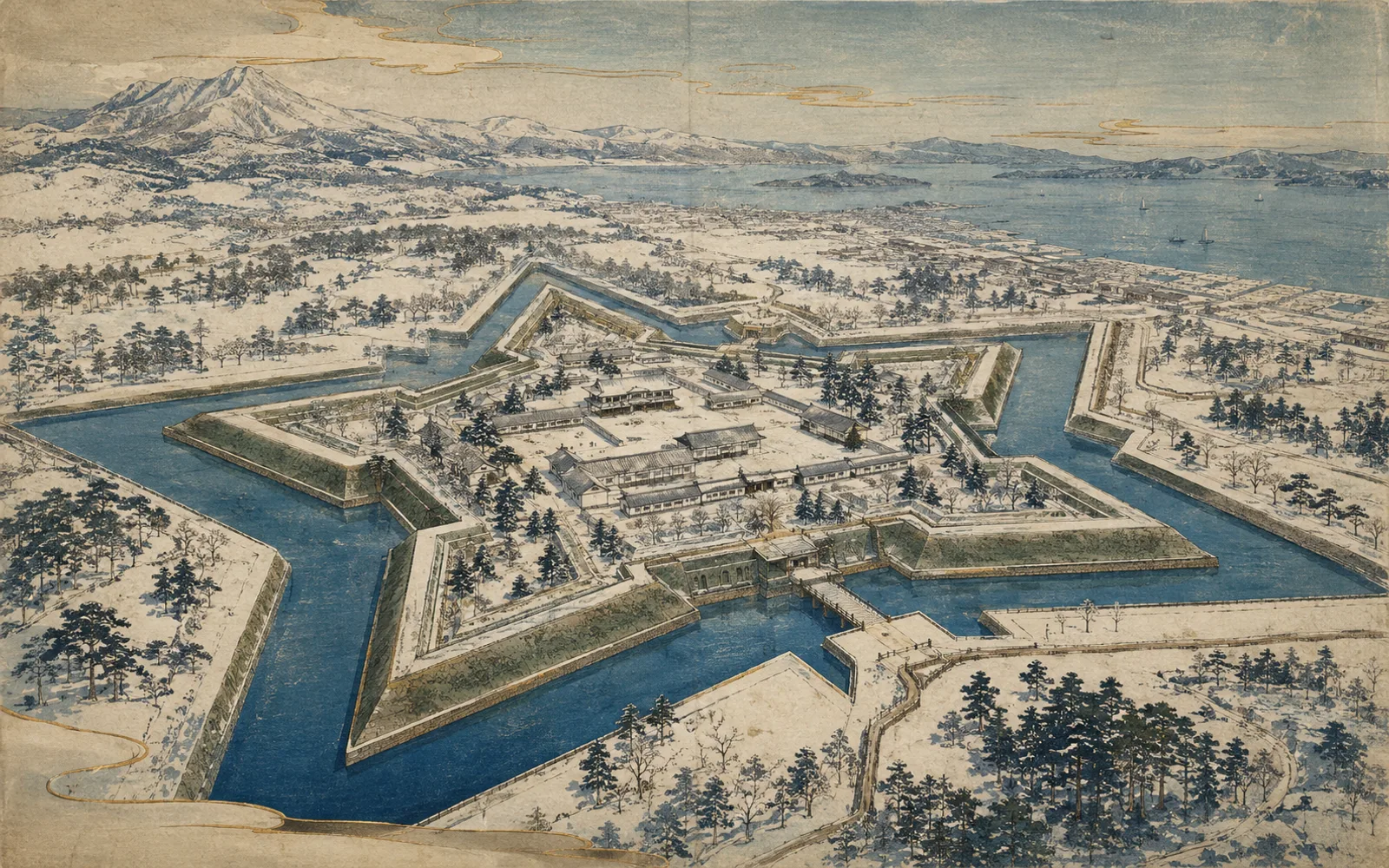
Goryokaku moves the atlas away from postcard keeps immediately: it was a late-Edo star fort built for the Hakodate magistracy, then became central to the final fighting of the Boshin War in Hokkaido.
History
What historically stood here
The Japan Castle Foundation records 五稜郭 as a 平城 site in 函館市, with the founding label 安政4年(1857). The listed builder or associated clan is 江戸幕府; principal lords are (箱館奉行).
The site’s history spans Late Edo, Boshin War, Meiji preservation.
Today
What you are actually seeing today
You are mainly seeing the star-shaped earthwork, moat geometry, park landscape, reconstructed magistrate office context, and a preserved military plan rather than an original medieval keep.
- Current condition
- Stonework and earthworks
- Terrain
- Hirajiro: flatland castle
- Condition note
- Stonework or earthworks only. Classified 2026-09-24 from the structured fields at https://cmeg.jp/w/castles/1.
Architecture And Defense
How to read the place
- star-fort plan
- moats
- late-Edo defensive geometry
Cultural-property notes in the Foundation row: 国指定特別史跡.
Visit
Present-day visitor information
Public park and visitor site; check Hakodate City for current facility access.
- Address or access location
- 北海道函館市函館市五稜郭町本通1
- Coordinates
- 41.796888, 140.756986
- Nearest useful station
- Goryokaku-koen-mae tram stop / Hakodate Station by bus or tram
- Estimated visit duration
- 2-3 hours
- Opening hours
- Check the official visitor source.
- Admission
- Check the official visitor source.
Seasonal planning note
- Spring blossom crowds are likely around Goryokaku Park.
Nearby
Castles close enough to compare
Shinori Date
Hokkaido / Stonework and earthworks
Kaminokuni Katsuyama Date
Hokkaido / Mountain castle ruins
Matsumae Castle
Hokkaido / Rebuilt or replica keep
Namioka Castle
Aomori / Stonework and earthworks
Sources
Source and correction context
Identity, list membership, Foundation list number, municipality, basic classification and cultural-property notes are source-verified. Site-level visitor details require additional review unless this record is publishable. Foundation numbers are official list identifiers, not rankings. Coordinates use the Foundation-linked position-data KML and should be treated as visitor-planning coordinates rather than archaeological survey points.
Sources
- Japan's Top 100 and Continued Top 100 Castle Position Data, Japan Castle Foundation / Nippon Castle. Accessed 2026-09-04. Used for the 200 castle addresses and coordinates exposed through the public map linked from the Japan Castle Foundation castle-search page.
- Japan's Top 100 Castles, Japan Castle Foundation. Accessed 2026-09-04. Used for the official identity, list number, list membership, location municipality, castle type, founding label, builders, principal lords, cultural-property notes, and keep-status notes for the original 100-castle selection.
- 100 Fine Castles of Japan and Continued 100 Fine Castles of Japan, Wikipedia contributors. Accessed 2026-09-04. Used only as a secondary cross-check for common English castle names; Japan Castle Foundation records remain the corpus source of truth.
- Nippon Shiro Meguri castle records: keep structure, remains and rebuilt structures, Nippon Shiro Meguri (cmeg.jp). Accessed 2026-09-24. Structured fields for each of the 200 castles, used to classify what stands at each site today. The linked record for each castle is its coordinate source.